


Learn about watersheds in general and what is happening
in West Niagara.

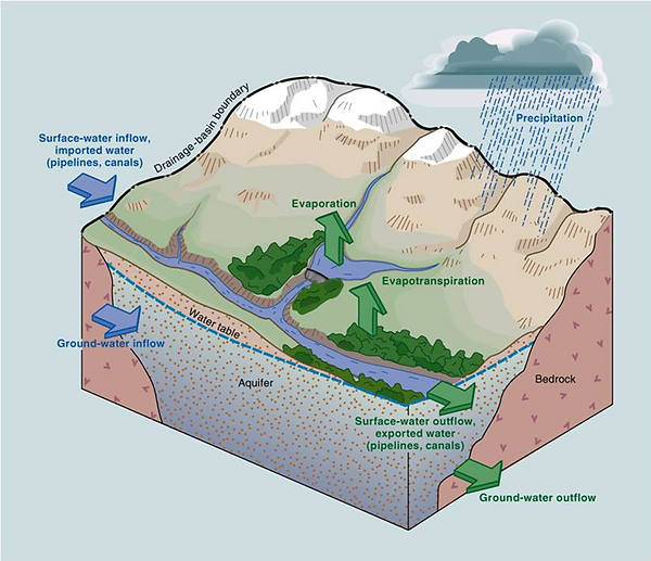
What is a watershed?
It’s a land area that channels rainfall and snowmelt to creeks, streams, and rivers, and eventually to outflow points such as reservoirs, bays, and the ocean.
While some watersheds are relatively small, others encompass thousands of square miles and may contain streams, rivers, lakes, reservoirs, and underlying groundwater that are hundreds of miles inland.
Water from hundreds, and often thousands, of creeks and streams flow from higher ground to rivers that eventually wind up in a larger waterbody. As the water flows, it often picks up pollutants, which may have sinister effects on the ecology of the watershed and, ultimately, on the reservoir, bay, or ocean where it ends up.
Not all water flows directly to the sea, however. When rain falls on dry ground, it can soak into, or infiltrate, the ground. This groundwater remains in the soil, where it will eventually seep into the nearest stream. Some water infiltrates much deeper, into underground reservoirs called aquifers. In other areas, where the soil contains a lot of hard clay, very little water may infiltrate. Instead, it quickly runs off to lower ground.
Rain and snowmelt from watersheds travel via many routes to the sea. During periods of heavy rain and snowfall, water may run onto and off of impervious surfaces such as parking lots, roads, buildings, and. other structures because it has nowhere else to go. These surfaces act as "fast lanes" that transport the water directly into storm drains. The excess water volume can quickly overwhelm streams and rivers, causing them to overflow and possibly result in floods1.
A more detailed understanding of a Watershed
A watershed is the area of land that drains into rivers and lakes, which, in turn, flow to a common outlet. Groundwater discharge is included in the watershed, although boundaries may not coincide exactly with surface water. Smaller drainage areas that feed into sub-watersheds, may be referred to as drainage basins or catchments. Watersheds may also drain into river basins, which can encompass larger areas.
Established watersheds are separated from one another by the height of the land, also known as drainage divides. Drainage divides are said to delineate the watershed.
Watersheds are nested systems, with smaller ones nesting into larger ones. The streams that form watersheds can be classified by an ordering framework. For example, headwater streams, which are at the highest elevation in the watershed, are first-order streams.
When two first-order streams join they become a second-order stream. And when two second-order streams join they form a third-order stream. A stream joined by a lower-order stream remains the same order. For example, a third-order stream joined by a first-order or second-order stream remains a third-order stream.
There is a close relationship between drainage patterns in a watershed and the underlying sediment or bedrock. Structural features such as faults and fractures can also influence the drainage pattern. Each watershed is unique. Characteristics include, but are not limited to, the total area of the watershed, its shape, the arrangement of slopes and the overall relief or elevation change. Additional characteristics include the form of its drainage network, the types and arrangement of vegetation cover, the nature of the soils, the geology, and land-use patterns.
To gain a good understanding of how these various characteristics interact, it is important to have access to climactic data, agricultural practice information, hydrological data, environmental data, aerial photos, topographic maps, and geological maps.
Other useful information includes soil maps, water resource and water quality data, land zoning and land use data, forestry maps and data, vegetation maps, water rights and wastewater disposal data, and aquatic and terrestrial habitat data.
Watershed management is a continuous process. It requires a multi-disciplinary approach, the use of sound science, and the implementation of well-planned actions to achieve specific physical objectives. The goal is to enhance and protect our water quality and environmental health on an individual/ watershed basis. We know that improving land management practices upstream can often maximize water quality and availability downstream. There are numerous beneficial management practices (BMPs) designed to mitigate human impacts originating at upstream locations. Impacts to headwaters can affect current or future watershed function, resources and usage.
The physical boundaries of watersheds seldom coincide with political boundaries, administrative planning or management units; therefore, a significant part of watershed management involves balancing competing interests and resolving conflicts between upstream and downstream users of the resource. Conflicts can arise when upstream users appear to bear the costs while downstream users reap the benefits2.
How is our local watershed monitored and protected in the Niagara Region?
STREAM FLOW MONITORING
The Niagara Peninsula Conservation Authority monitors stream flow, rainfall and other meteorological information at locations across the watershed. The information is transmitted from each station to the NPCA’s Head Office in Welland, Ontario, in near-real time where it is monitored and analyzed. The data gives us an up to date picture of the conditions within the watershed and allows us to develop a deeper understanding of the fluxes and behaviour of the systems.
WATER QUALITY MONITORING
Since 2001, the NPCA has developed an extensive water quality monitoring program within its jurisdiction. This program includes monitoring the surface water of major and smaller watercourses and monitoring significant groundwater aquifers. The information generated through this program helps the NPCA understand how surface water and groundwater systems function and provides information about their overall health.
The NPCA monitoring network is operated in partnership with the municipalities and Ontario Ministry of
Environment Conservation and Parks with the Provincial Water Quality Monitoring Program and Provincial Groundwater Monitoring Program. The main objective of this program is to assess water quality in local watersheds using a network of chemical and biological monitoring stations. The NPCA and its partners can use this knowledge to provide programs and develop policies to protect and improve the water resources within the watershed.
What is Our Water Quality Data Telling Us?
Most of the surface water monitoring sites in NPCA watershed have poor water quality. Nutrient and bacteria contamination from non-point sources (agricultural/livestock runoff and faulty septic systems) and point sources (combined sewer overflow) continue to be the major causes of water quality impairment in the NPCA watershed.
The groundwater quality at most NPCA monitoring wells is good but some wells did exceed Ontario Drinking Water Standards. Most well exceedances were attributed to natural bedrock conditions. Groundwater levels at most wells vary seasonally with their highest water levels being observed during the late winter and early spring but drop to their lowest level during the fall months.
SURFACE WATER MONITORING
The NPCA collects surface water samples eight times a year on a monthly basis during ice-free periods from a network of 80 surface water sampling sites across the NPCA watershed. When collecting samples the NPCA test the water in the field for temperature, dissolved oxygen and conductivity but also submits samples to laboratory analysis for numerous parameters, including general chemistry, nutrients, metals and bacteria. This water chemistry program is operated in partnership with the Ontario’s Provincial Water Quality Monitoring Network and the Niagara Region.
The NPCA also has an in-depth biological monitoring program, the goal of which is to assess aquatic ecosystems using benthic invertebrates as indicators of water quality. Benthic macroinvertebrates are large, bottom dwelling insects such as crustaceans, worms, mollusks and related organisms that live in the water. They are good indicators of water quality as they respond to changes in water quality. The NPCA uses Ontario Benthos Biomonitoring Network Protocol for its biological monitoring program. Overall, this monitoring of water chemistry and benthic macroinvertebrates allows the NPCA to identify potential sources/causes of poor stream health and target effective strategies to improve stream health within our watershed.
GROUNDWATER MONITORING
A network of groundwater monitoring wells has been established across the watershed to monitor the quality and quantity of the groundwater resources in the region. The NPCA groundwater monitoring program consists of 31 NPCA wells and 15 wells through the Ontario Provincial Groundwater Monitoring Network which monitor a number of different aquifers. Data from these wells is being used to make informed decisions about water testing and treatment of private wells, water allocation (under the MECP’s Permit To-Take-Water program), drinking water source protection planning and potential climate change impacts. Results from water quality sampling areas are used to inform municipalities of any exceedances of the Ontario Drinking Water Standards that might occur in aquifers within their jurisdiction.
Where Do You find the Best Water Quality in the NPCA Watershed?
The upper Twelve Mile Creek tributaries have the best naturally occurring water quality due to large input of groundwater. Other watersheds such the Lower Twelve Mile Creek, Lower Welland River and Welland Canal have good water quality owing to the strong influence of water input of Lake Erie and the Niagara River.
How Can We Improve Water Quality in our Watersheds?
Surface Water
-
Plant vegetative buffers along watercourses for shade and to filter pollutants.
-
Implement agricultural Best Management Practices in rural areas which reduce soil erosion, and limit nutrient and bacteria runoff.
-
In urban areas, implement stormwater planning using Low Impact Development, stormwater
-
Best Management Practices, erosion control, and upgrade sewer systems.
Groundwater
-
Ensure wells are properly sealed and cased. Poorly constructed casings allow surface water to
seep along the outside of the casing into groundwater. -
Locate wells up-slope and away from sources of contaminants. Locate wells away and up-slope from septic systems, manure storage areas and feedlots. Maximizing the distance between the well and contaminant sources minimizes the risk of contamination.
-
Properly plug abandoned and unused wells. Abandoned wells are a serious risk to groundwater
quality. Improperly plugged wells can act as a direct conduit for contaminants to reach groundwater. 3
View the Watershed Report Card - 2023 here